
Regulation — Belgium
Preparing a drone flight in Belgium: maps, geozones and authorizations
Preparing a mission in Belgium requires three things that are often confused: an official map of regulated zones, a counter at which to obtain permission to fly in them, and an operator file that is in order. All three exist, they are public and free, but they are not equivalent and cannot replace one another. Here is what each one does, the real lead times, and the private applications that come on top.
Three public services, three distinct roles

The reference map is Droneguide, published at map.droneguide.be. The Directorate-General for Air Transport (DGTA) publishes the UAS geographical zones there under Article 15 of Implementing Regulation (EU) 2019/947. The content of these zones — boundaries, floors, ceilings, activation times, access conditions — is set by the Ministerial Decree of 21 December 2020, amended several times since. The application is operated by skeyes, which entrusts its mapping engine to the Antwerp-based company Unifly.
Each zone has a designated manager, responsible for issuing prior flight authorisations according to written procedures supervised by the DGTA. This explains the number of different counters: skeyes for the approaches to Brussels, Antwerp, Charleroi, Liège and Ostend airports and for the Courtrai-Wevelgem RMZ; Defence for its sites and training areas; other managers for uncontrolled aerodromes, heliports, model flying sites, UAS test areas, the Port of Antwerp-Bruges and the royal estates. Prisons and nuclear installations additionally require technical means: geo-awareness and direct remote identification of the remote pilot.
The second building block is the Drones & Aerial Activities (DAA) tool, developed by SkeyDrone, a skeyes subsidiary. It does not cover the whole of Belgium: only the six skeyes geozones and the zones managed by Defence. The Planner module is used to file and track the operation, the Fly module to confirm it on the day, to report take-off, landing and closure.
The third building block is the DGTA's Drone Portal, accessible via eID or itsme. It carries operator registration — compulsory from 250 g, or as soon as a sensor can record personal data — the A1/A3 online exam, standard scenario declarations, specific category operational authorisation applications and LUC applications. The portal issues an operator number in the form BEL followed by thirteen characters, to be affixed to each drone.
The distinction to remember: a geozone authorisation comes from the zone manager, an operational authorisation comes from the DGTA. A flight may require both.
The DAA lead times, and what they really impose
The five airport geozones are divided into three VLL (very low level) sub-zones according to distance from the runways, and the Courtrai RMZ into two. The timetable depends on the sub-zone, and it is shorter than many operators imagine.
An operation is filed between the day before and three hours before the planned start, for VLL0, VLL1 and EBKT RMZ1. In VLL2 and EBKT RMZ2, the request is processed automatically at H-3. The assessment itself can take time: depending on the sub-zone, the reply arrives immediately or up to eight working days later. Filing a VLL0 operation the previous evening is therefore a lottery.
Once the pre-authorisation has been obtained, an explicit confirmation is required for VLL0, VLL1 and RMZ1: it opens the day before and closes three hours before the flight. In VLL2, it is automatic. Then comes the tactical authorisation, on the day. In VLL0, in VLL1 and in the Brussels VLL2 above 150 ft above aerodrome level and more than 50 metres from an obstacle, air traffic control must be contacted thirty minutes before the start of the operation, by VHF radio or by telephone. Elsewhere, authorisation is granted without contact, with control able to call the remote pilot back to give instructions.
During the flight, the Fly module requires three notifications: take-off, landing, closure. An operator may take off and land several times within its window, but must close in order to release the airspace.
The volume gives a measure of the activity: skeyes granted 16,381 flight authorisations in 2024 in its CTRs and the Courtrai RMZ, up 6% year on year. Since June 2025, the company has been certified as a common information service provider (CISP), the component that exchanges data between manned and unmanned aviation. On large industrial sites, the chain is being privatised: the Port of Antwerp-Bruges operates a UTM developed by Unifly with SkeyDrone, with its own access conditions.
Comparison of the tools available for Belgium
No tool replaces the others. The limitations column matters as much as the price: that is where the nasty surprises of the day itself lie. Prices recorded in November 2026.
| Tool | What it does | Price | Strengths | Limitations |
|---|---|---|---|---|
| Droneguide (web and app) | National map of geozones, access conditions, planned activations | Free | Official DGTA source, forecast layer up to 30 days ahead, logbook in the mobile application | Does not include the authorisation request outside skeyes zones; activation status must be rechecked before take-off |
| DAA Planner and DAA Fly | Filing and tracking of authorisations in skeyes and Defence zones, confirmation and tactical authorisation | Free, provided by skeyes | Automatic validation in VLL2, integrated take-off notification, crew and drone registered once | Restricted to skeyes and Defence zones; filing only between D-1 and H-3, assessment up to 8 working days |
| Drone Portal (DGTA) | Operator registration, A1/A3 exam, STS declarations, specific authorisations, LUC | Free | Single official channel, access via eID or itsme, operator number valid throughout the EU | Austere ergonomics; a specific authorisation assessment must be prepared weeks in advance |
| DJI Fly Safe and GEO Zone | Display of zones in the application and in the drone, possible blocking | Free, built into the hardware | Immediate alert to the pilot, with no configuration | Geozones imported from Droneguide without activation status or access conditions |
| SafeSky and SafeSky Sentinel | Traffic awareness (ADS-B, FLARM, Mode S), sharing of the operation's position | Free; Premium at €34.99 including VAT per year | Aggregates around thirty traffic sources, Sentinel free for drone crews | Does not tell you where to fly; effectiveness depends on other aircraft taking part |
| Drone Assist (Altitude Angel) | Planning, NOTAMs, zones, filing of approval requests | Free; approvals depend on the services | Polished interface, NOTAM and ground hazard layers | Data designed for the United Kingdom, generic Belgian coverage |
| skeyes AIM-METEO and EAD NOTAMs | Temporary restrictions: events, exercises, State visits | Free, EAD account required | The only reliable source for the day's restrictions | Aeronautical reading, no drone-oriented rendering |
| Unifly (map and port UTM) | Mapping engine behind Droneguide; Port of Antwerp-Bruges UTM | Free public consultation; UTM by quotation | Foundation used by the Belgian ANSP, UTM component for sensitive sites | Public version read-only; the UTM targets large operators |
The minimum chain consists of three steps: check the geozone on Droneguide, file the operation in DAA if the zone requires it, contact the manager for non-skeyes zones. Private applications come afterwards, as aids to preparation or monitoring, never as a regulatory source of truth.
What private maps cannot tell you
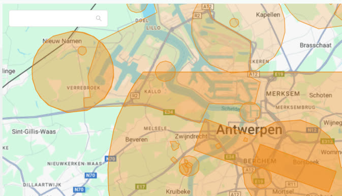
DJI has aligned its GEO Zone map with the Belgian data: Droneguide geozones are imported and displayed as enhanced warning zones. The manufacturer acknowledges that this integration carries neither the activation status nor the access conditions. A pilot who trusts the green on their controller screen can therefore take off in an active zone without authorisation. SkeyDrone, which documented this shift, reminds users that checking on Droneguide remains mandatory.
Traffic awareness tools answer a different question, namely who is flying around you. SafeSky, a Belgian company, aggregates ADS-B, FLARM and several partner networks; its Sentinel application, free of charge, is dedicated to drone crews. Useful in uncontrolled airspace, useless for knowing whether you are allowed to take off. Drone Assist, very comprehensive in the United Kingdom, remains generic in Belgium and does not replace the ANSP's data.
Two blind spots remain, which aerial geozones do not cover. The first is temporary: the NOTAMs published by skeyes via its AIM-METEO briefing, and by EUROCONTROL via EAD, carry closures linked to an event or an exercise, including in zones that were free the day before. The second is regional and falls under environmental law. In Wallonia as in Flanders, flying over nature reserves depends on authorisation from the site manager: the Department of Nature and Forests, or the owner for domain and approved reserves on the Walloon side, and the Agentschap voor Natuur en Bos on the Flemish side. These rules do not appear in Droneguide because they do not fall within airspace. A complete file checks them separately, with the site manager.
The sequence, from desk to take-off
Operator registration is done once, on the Drone Portal, and the BEL number is affixed to the aircraft. Next comes verification of the geozone at the exact address of the site, not at the scale of the municipality: Droneguide lets you search for an address and displays the access conditions of each zone concerned.
If the take-off point falls within a skeyes or Defence zone, the operation is created in DAA Planner with the operator-admin, the remote pilot, the UAS, the zone and the requested documents. Filing takes place between D-1 and H-3, earlier if the zone is in VLL0 or VLL1. Confirmation follows, then contact with control thirty minutes before the flight where the zone requires it.
On the day, the routine comes down to four checks: NOTAMs and temporary restrictions, activation status of the geozone, weather and local airspace, remote identification means active. The Fly module records take-off, landing and closure. What remains is the logbook and insurance, which the zone manager may request during an inspection.
Information verified on: 2026-11-04.
DAA lead times, the prices of private applications and the list of geozone managers change; the sources below are authoritative.
← Back to home · Search · Suggest a topic · Lire en français / Read in French